


2022-02-07_15h57m19_Pic_Coudère_-_Pic_d'Engral-13521318-1644245335-617

chrisgps
User
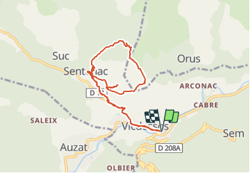

Length
9.7 km

Max alt
1315 m

Uphill gradient
699 m
Km-Effort
19.1 km

Min alt
706 m

Downhill gradient
699 m
Boucle
Yes
Creation date :
2022-02-07 14:57:20.17
Updated on :
2022-02-07 14:57:23.688

FREE GPS app for hiking
 SityTrail
IGN / Geographical institutes
SityTrail Plus
The world is yours!
About
Trail of 9.7 km to be discovered at Occitania, Ariège, Val-de-Sos. This trail is proposed by chrisgps.
Positioning
Country:
France
Region :
Occitania
Department/Province :
Ariège
Municipality :
Val-de-Sos
Location:
Unknown
Start:(Dec)
Start:(UTM)
377381 ; 4736171 (31T) N.
Comments