Havel Montegnet Oss Sawhis

Pierrot
User
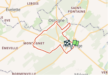

Length
12.1 km

Max alt
319 m

Uphill gradient
221 m
Km-Effort
15.1 km

Min alt
228 m

Downhill gradient
221 m
Boucle
Yes
Creation date :
2022-02-07 13:07:43.758
Updated on :
2022-02-07 15:51:17.907
2h42
Difficulty : Difficult
1h30
Difficulty : Very easy

FREE GPS app for hiking
 SityTrail
IGN / Geographical institutes
SityTrail Plus
The world is yours!
About
Trail Walking of 12.1 km to be discovered at Wallonia, Namur, Havelange. This trail is proposed by Pierrot .
Positioning
Country:
Belgium
Region :
Wallonia
Department/Province :
Namur
Municipality :
Havelange
Location:
Unknown
Start:(Dec)
Start:(UTM)
659114 ; 5583740 (31U) N.
Comments