


Mont vaudois guinottes

Danielj
User
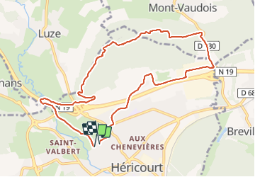

Length
10.1 km

Max alt
528 m

Uphill gradient
280 m
Km-Effort
13.8 km

Min alt
328 m

Downhill gradient
273 m
Boucle
Yes
Creation date :
2022-02-07 13:51:45.0
Updated on :
2022-02-07 16:15:10.474
2h22
Difficulty : Difficult

FREE GPS app for hiking
 SityTrail
IGN / Geographical institutes
SityTrail Plus
The world is yours!
About
Trail Walking of 10.1 km to be discovered at Bourgogne-Franche-Comté, Haute-Saône, Héricourt. This trail is proposed by Danielj.
Positioning
Country:
France
Region :
Bourgogne-Franche-Comté
Department/Province :
Haute-Saône
Municipality :
Héricourt
Location:
Héricourt
Start:(Dec)
Start:(UTM)
330972 ; 5271901 (32T) N.
Comments