


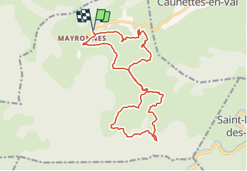
Loop of Mayronnes

PI11
User

Length
10.5 km

Max alt
384 m

Uphill gradient
373 m
Km-Effort
15.5 km

Min alt
238 m

Downhill gradient
372 m
Boucle
Yes
Creation date :
2022-02-08 11:19:08.184
Updated on :
2022-02-08 11:26:54.571
3h31
Difficulty : Easy

FREE GPS app for hiking
 SityTrail
IGN / Geographical institutes
SityTrail Plus
The world is yours!
About
Trail On foot of 10.5 km to be discovered at Occitania, Aude, Mayronnes. This trail is proposed by PI11.
Description
Hike from Mayronnes.
The route follows a part of the sculptural path.
So there is a sculpture exhibit on part of the trail.
See https://youtu.be/3bUIzlEetSk


Positioning
Country:
France
Region :
Occitania
Department/Province :
Aude
Municipality :
Mayronnes
Location:
Unknown
Start:(Dec)
Start:(UTM)
461605 ; 4767343 (31T) N.
Comments