


La Hé de Fer

Commissariat général au Tourisme
Randonnées du CGT GUIDE+

Length
19.6 km

Max alt
331 m

Uphill gradient
434 m
Km-Effort
25 km

Min alt
162 m

Downhill gradient
434 m
Boucle
Yes
Creation date :
2022-02-08 11:32:13.036
Updated on :
2022-02-21 10:13:03.683
5h45
Difficulty : Medium

FREE GPS app for hiking
 SityTrail
IGN / Geographical institutes
SityTrail Plus
The world is yours!
About
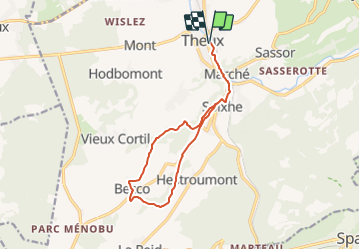
Trail On foot of 19.6 km to be discovered at Wallonia, Liège, Theux. This trail is proposed by Commissariat général au Tourisme.
Description
Trail created by Spa Hautes Fagnes Ardennes.
Positioning
Country:
Belgium
Region :
Wallonia
Department/Province :
Liège
Municipality :
Theux
Location:
Theux
Start:(Dec)
Start:(UTM)
699456 ; 5601877 (31U) N.
Comments