


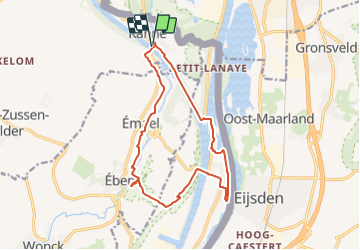
Lanaye (I2-4 Rouge) : Par delà les rives - Montagne Saint-Pierre

Commissariat général au Tourisme
Randonnées du CGT GUIDE+

Length
13.2 km

Max alt
116 m

Uphill gradient
173 m
Km-Effort
15.5 km

Min alt
46 m

Downhill gradient
172 m
Boucle
Yes
Creation date :
2022-02-08 11:32:51.759
Updated on :
2022-02-21 10:14:17.077
3h31
Difficulty : Easy

FREE GPS app for hiking
 SityTrail
IGN / Geographical institutes
SityTrail Plus
The world is yours!
About
Trail On foot of 13.2 km to be discovered at Flanders, Limburg, Riemst. This trail is proposed by Commissariat général au Tourisme.
Description
Trail created by Pays de Herve.
Photos
 : Par delà les rives - Montagne Saint-Pierre - Photo 1")
 : Par delà les rives - Montagne Saint-Pierre - Photo 2")
Positioning
Country:
Belgium
Region :
Flanders
Department/Province :
Limburg
Municipality :
Riemst
Location:
Kanne
Start:(Dec)
Start:(UTM)
688174 ; 5632238 (31U) N.
Comments