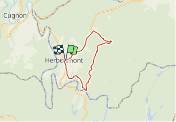
Trail On foot Herbeumont - L'Antrogne - Photo

Randonnées du CGT GUIDE+

© OpenStreetMap contributors
Length
Length
9.3 km
Max alt
Max alt
433 m
Uphill gradient
Uphill gradient
271 m
Km-Effort
Km-Effort  
12.9 km
Min alt
Min alt
273 m
Downhill gradient
Downhill gradient
275 m
Boucle
Boucle
Yes
Creation date :
2022-02-08 11:33:20.953
Updated on :
2022-02-21 10:14:40.31

(1 Reviews)

On foot
On foot
2h56
Difficulty : Easy

Scan this QR Code to open this trail in the SityTrail application

FREE GPS app for hiking

Logo SityTrail SityTrail

IGN / Geographical institutes

Download SityTrail from the App Store Download SityTrail from Google Play

Logo SityTrail SityTrail Plus

The world is yours!

Download SityTrail from the App Store Download SityTrail from Google Play Download SityTrail on Huawei AppGallery

About

Trail On foot of 9.3 km to be discovered at Wallonia, Luxembourg, Herbeumont. This trail is proposed by Commissariat général au Tourisme.

Description

Trail created by Pays de Bouillon en Ardenne.


The highlight of the hike is at the lowest point: the mouth of the Antrogne in the Semois. Nice path through the deciduous forests before arriving at the bathing resort. However, this path is in bad shape at the start.


Elevation profile

Photos

Positioning

Country:
Belgium
Region :
Wallonia
Department/Province :
Luxembourg
Municipality :
Herbeumont
Location:
Unknown
Start:(UTM)
661187 ; 5516704 (31U) N.

Comments

Please log in to post a review or rate the element


Leuke tocht. Je start eerst langs een weg, wat minder fijn is. Nadien enkel zandwegen tot wandelwegjes. Mooie uitzichten en veel natuur.


Close
My subscriptions