


les Balmes

HAL26
User
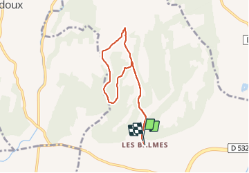

Length
7 km

Max alt
279 m

Uphill gradient
182 m
Km-Effort
9.4 km

Min alt
172 m

Downhill gradient
183 m
Boucle
Yes
Creation date :
2022-02-08 13:44:50.085
Updated on :
2022-02-08 15:27:21.01
1h42
Difficulty : Medium

FREE GPS app for hiking
 SityTrail
IGN / Geographical institutes
SityTrail Plus
The world is yours!
About
Trail Walking of 7 km to be discovered at Auvergne-Rhône-Alpes, Drôme, Romans-sur-Isère. This trail is proposed by HAL26.
Positioning
Country:
France
Region :
Auvergne-Rhône-Alpes
Department/Province :
Drôme
Municipality :
Romans-sur-Isère
Location:
Unknown
Start:(Dec)
Start:(UTM)
658327 ; 4991771 (31T) N.
Comments