


odile

psesjs
User
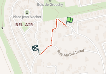

Length
332 m

Max alt
551 m

Uphill gradient
18 m
Km-Effort
512 m

Min alt
530 m

Downhill gradient
0 m
Boucle
No
Creation date :
2022-02-08 15:46:45.274
Updated on :
2022-02-08 15:52:31.305
5m
Difficulty : Easy

FREE GPS app for hiking
 SityTrail
IGN / Geographical institutes
SityTrail Plus
The world is yours!
About
Trail Walking of 332 m to be discovered at Auvergne-Rhône-Alpes, Loire, Saint-Étienne. This trail is proposed by psesjs.
Positioning
Country:
France
Region :
Auvergne-Rhône-Alpes
Department/Province :
Loire
Municipality :
Saint-Étienne
Location:
Unknown
Start:(Dec)
Start:(UTM)
607659 ; 5035075 (31T) N.
Comments