


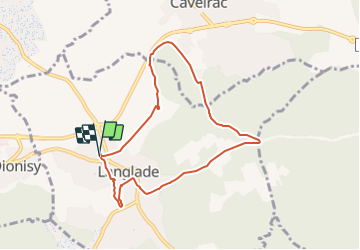
Langlade - Voie-verte Fontaine

rando30129
User

Length
7.8 km

Max alt
129 m

Uphill gradient
102 m
Km-Effort
9.1 km

Min alt
68 m

Downhill gradient
100 m
Boucle
Yes
Creation date :
2022-02-08 13:04:53.382
Updated on :
2023-12-13 09:34:34.361
2h04
Difficulty : Medium

FREE GPS app for hiking
 SityTrail
IGN / Geographical institutes
SityTrail Plus
The world is yours!
About
Trail Walking of 7.8 km to be discovered at Occitania, Gard, Langlade. This trail is proposed by rando30129.
Photos


Positioning
Country:
France
Region :
Occitania
Department/Province :
Gard
Municipality :
Langlade
Location:
Unknown
Start:(Dec)
Start:(UTM)
600198 ; 4851140 (31T) N.
Comments