


Domblans Randonnée

daniellebou
User
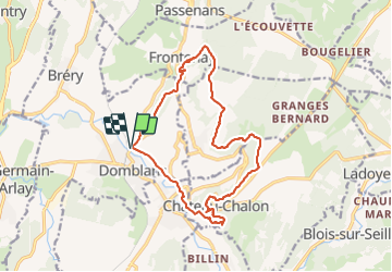

Length
17.2 km

Max alt
493 m

Uphill gradient
452 m
Km-Effort
23 km

Min alt
242 m

Downhill gradient
450 m
Boucle
Yes
Creation date :
2022-02-09 10:29:50.323
Updated on :
2022-02-13 23:23:10.985
5h16
Difficulty : Very difficult

FREE GPS app for hiking
 SityTrail
IGN / Geographical institutes
SityTrail Plus
The world is yours!
About
Trail Walking of 17.2 km to be discovered at Bourgogne-Franche-Comté, Jura, Domblans. This trail is proposed by daniellebou.
Positioning
Country:
France
Region :
Bourgogne-Franche-Comté
Department/Province :
Jura
Municipality :
Domblans
Location:
Domblans
Start:(Dec)
Start:(UTM)
698531 ; 5182563 (31T) N.
Comments