


Fabras Echelette

Rudy07
User

Length
5.7 km

Max alt
526 m

Uphill gradient
212 m
Km-Effort
8.6 km

Min alt
380 m

Downhill gradient
210 m
Boucle
Yes
Creation date :
2022-02-09 11:11:37.351
Updated on :
2023-12-28 14:51:09.575
1h57
Difficulty : Medium

FREE GPS app for hiking
 SityTrail
IGN / Geographical institutes
SityTrail Plus
The world is yours!
About
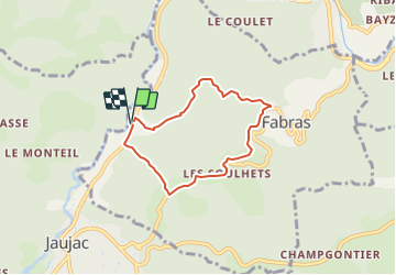
Trail Walking of 5.7 km to be discovered at Auvergne-Rhône-Alpes, Ardèche, Fabras. This trail is proposed by Rudy07.
Description
FABRAS – Pont de l’Echelette (parking Belvédère avant l’entrée de Jaujac). Bonneval – Fabras - Les Souilhets – l’Armande.
Positioning
Country:
France
Region :
Auvergne-Rhône-Alpes
Department/Province :
Ardèche
Municipality :
Fabras
Location:
Unknown
Start:(Dec)
Start:(UTM)
600355 ; 4944807 (31T) N.
Comments