


Pont Coblant

poupartbertrand
User
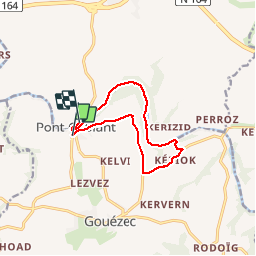

Length
10 km

Max alt
91 m

Uphill gradient
137 m
Km-Effort
11.8 km

Min alt
25 m

Downhill gradient
138 m
Boucle
No
Creation date :
2014-12-10 00:00:00.0
Updated on :
2014-12-10 00:00:00.0
2h09
Difficulty : Easy

FREE GPS app for hiking
 SityTrail
IGN / Geographical institutes
SityTrail Plus
The world is yours!
About
Trail Walking of 10 km to be discovered at Brittany, Finistère, Gouézec. This trail is proposed by poupartbertrand.
Description
Circuit
Positioning
Country:
France
Region :
Brittany
Department/Province :
Finistère
Municipality :
Gouézec
Location:
Unknown
Start:(Dec)
Start:(UTM)
426707 ; 5337816 (30U) N.
Comments