


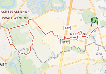
Geitepad

SityTrail - itinéraires balisés pédestres
Tous les sentiers balisés d’Europe GUIDE+


2h00
Difficulty : Easy

FREE GPS app for hiking
 SityTrail
IGN / Geographical institutes
SityTrail Plus
The world is yours!
About
Trail On foot of 8.2 km to be discovered at Flanders, Antwerp, Antwerp. This trail is proposed by SityTrail - itinéraires balisés pédestres.
Description
Trail created by Toerisme Provincie Antwerpen.
Wandelroute in Wilrijk, 19km - there's also a cycling route with minor deviations in Park Steytelinck, Fort 7, and the Vuurmolenstraat
Photos


Positioning
Comments