


Boerenkrijg wandelroute

SityTrail - itinéraires balisés pédestres
Tous les sentiers balisés d’Europe GUIDE+
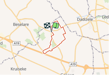

Length
8.1 km

Max alt
44 m

Uphill gradient
65 m
Km-Effort
8.9 km

Min alt
18 m

Downhill gradient
63 m
Boucle
Yes

Signpost
Creation date :
2022-02-09 15:07:53.769
Updated on :
2022-02-09 17:54:09.084
2h01
Difficulty : Easy

FREE GPS app for hiking
 SityTrail
IGN / Geographical institutes
SityTrail Plus
The world is yours!
About
Trail On foot of 8.1 km to be discovered at Flanders, West Flanders, Wervik. This trail is proposed by SityTrail - itinéraires balisés pédestres.
Description
Deze wandelrouteroute voert je doorheen het glooiend landschap van de Tabaksstreek.
Photos


Positioning
Country:
Belgium
Region :
Flanders
Department/Province :
West Flanders
Municipality :
Wervik
Location:
Geluwe
Start:(Dec)
Start:(UTM)
504164 ; 5632311 (31U) N.
Comments