Trail On foot Alveringem - Pannendorp wandelroute - Photo

Pannendorp wandelroute

Tous les sentiers balisés d’Europe GUIDE+

© OpenStreetMap contributors
Length
Length
8.2 km
Max alt
Max alt
6 m
Uphill gradient
Uphill gradient
26 m
Km-Effort
Km-Effort  
8.6 km
Min alt
Min alt
-2 m
Downhill gradient
Downhill gradient
25 m
Boucle
Boucle
Yes
Signpost
Signpost
Creation date :
2022-02-09 15:08:06.531
Updated on :
2022-02-09 17:54:16.394

(0 Reviews)

On foot
On foot
1h56
Difficulty : Easy

Scan this QR Code to open this trail in the SityTrail application

FREE GPS app for hiking

Logo SityTrail SityTrail

IGN / Geographical institutes

Download SityTrail from the App Store Download SityTrail from Google Play

Logo SityTrail SityTrail Plus

The world is yours!

Download SityTrail from the App Store Download SityTrail from Google Play Download SityTrail on Huawei AppGallery

About

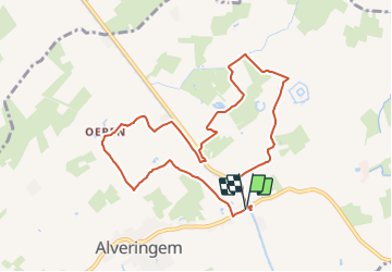
Trail On foot of 8.2 km to be discovered at Flanders, West Flanders, Alveringem. This trail is proposed by SityTrail - itinéraires balisés pédestres.

Description

De Pannendorproute start aan het Mout- en Brouwhuis De Snoek in Alveringem. Je verkent het landschap aan weerszijden van de Lovaart. Aan de rechteroever komt het tracé langs de Leerzevaart en een oude dakpannenfabriek met bijhorende arbeiderswoningen in het gehucht Fortem. Aan de linkeroever leidt de route naar Oeren, een dorpskern met een kerk, een Belgisch

Elevation profile

Photos

Positioning

Country:
Belgium
Region :
Flanders
Department/Province :
West Flanders
Municipality :
Alveringem
Location:
Alveringem
Start:(UTM)
480890 ; 5651618 (31U) N.


Close
My subscriptions