


Autopédestre Echternach 1

SityTrail - itinéraires balisés pédestres
Tous les sentiers balisés d’Europe GUIDE+
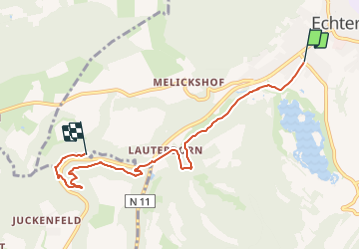

Length
11 km

Max alt
328 m

Uphill gradient
384 m
Km-Effort
16.1 km

Min alt
165 m

Downhill gradient
384 m
Boucle
Yes

Signpost
Creation date :
2022-02-09 15:10:01.88
Updated on :
2022-03-10 09:17:59.915
3h39
Difficulty : Easy

FREE GPS app for hiking
 SityTrail
IGN / Geographical institutes
SityTrail Plus
The world is yours!
About
Trail On foot of 11 km to be discovered at Unknown, Canton Echternach, Echternach. This trail is proposed by SityTrail - itinéraires balisés pédestres.
Description
Symbol: Blaue Fahne auf weißem Grund
Photos


Positioning
Country:
Luxembourg
Region :
Unknown
Department/Province :
Canton Echternach
Municipality :
Echternach
Location:
Unknown
Start:(Dec)
Start:(UTM)
314110 ; 5520791 (32U) N.
Comments