Trail Cycle Condrieu - Balade 2 Condrieu - Photo
 bosses21
bosses21

User

© OpenStreetMap contributors
Length
Length
55 km
Max alt
Max alt
950 m
Uphill gradient
Uphill gradient
1311 m
Km-Effort
Km-Effort  
73 km
Min alt
Min alt
142 m
Downhill gradient
Downhill gradient
1311 m
Boucle
Boucle
Yes
Creation date :
2014-12-10 00:00:00.0
Updated on :
2014-12-10 00:00:00.0

(0 Reviews)

Cycle
Cycle
4h07
Difficulty : Difficult

Scan this QR Code to open this trail in the SityTrail application

FREE GPS app for hiking

Logo SityTrail SityTrail

IGN / Geographical institutes

Download SityTrail from the App Store Download SityTrail from Google Play

Logo SityTrail SityTrail World

The world is yours!

Download SityTrail from the App Store Download SityTrail from Google Play Download SityTrail on Huawei AppGallery

About

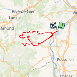
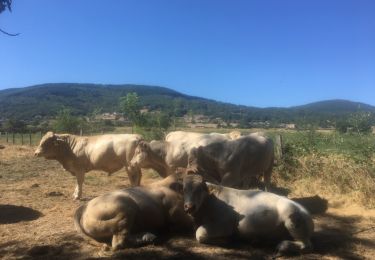
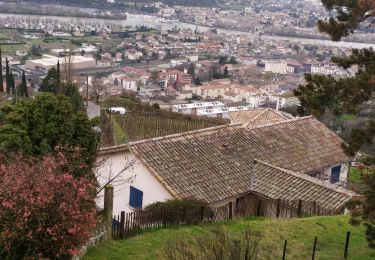
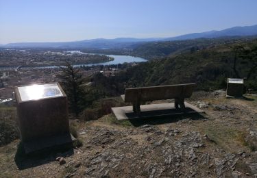
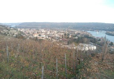
Trail Cycle of 55 km to be discovered at Auvergne-Rhône-Alpes, Rhône, Condrieu. This trail is proposed by bosses21.

Description

Col de Pavezin - 651m
Col de la croix du Mazet - 656m
Croix de Montvieux - 812m
Collet de Doizieux - 946m

Elevation profile

Points of interest

Point of interest Pavezin - Col de Pavezin - 651m - Photo
bosses21
Point of interest Sainte-Croix-en-Jarez - Col de la croix du Mazet - 656m - Photo
bosses21
SAINTE-CROIX-EN-JAREZ 
Point of interest Pélussin - Croix de Montvieux - 812m - Photo
bosses21
Point of interest Pélussin - Collet de Doizieux - 946m - Photo
bosses21

Positioning

Country:
France
Region :
Auvergne-Rhône-Alpes
Department/Province :
Rhône
Municipality :
Condrieu
Location:
Unknown
Start:(Dec)
Start:(UTM)
638895 ; 5035677 (31T) N.

Trails nearby

Trail Walking Condrieu - ravin de l'arbuet - Photo
Walking
dan69390

Walking

Very easy
(1)
Condrieu, Auvergne-Rhône-Alpes, Rhône, France
7.2 km | 10 km-effort
2h 52min
Yes
Trail Walking Reventin-Vaugris - 38-reventin-10km-325m - Photo
Walking
SyMA

Walking

Easy
Reventin-Vaugris, Auvergne-Rhône-Alpes, Isère, France
10 km | 14.3 km-effort
3h 5min
Yes
Trail On foot La Chapelle-Villars - Pilat N°30: des «Côteaux à les Haies» - Photo
On foot
PRO

On foot

Difficult
La Chapelle-Villars, Auvergne-Rhône-Alpes, Loire, France
29 km | 37 km-effort
8h 27min
Yes
Trail Walking Vérin - 42-Vérin  Chuyer 18km 520m 18/5/20 - Photo
Walking
SyMA

Walking

Medium
Vérin, Auvergne-Rhône-Alpes, Loire, France
17.6 km | 25 km-effort
5h 12min
Yes
Trail Running Condrieu - Condrieu - Photo
Running
maelow

Running

Easy
Condrieu, Auvergne-Rhône-Alpes, Rhône, France
17.5 km | 23 km-effort
2h 23min
Yes
Trail Walking Condrieu - condrieu - Photo
Walking
Jean-Luc Villermaux

Walking

Difficult
Condrieu, Auvergne-Rhône-Alpes, Rhône, France
14 km | 18.7 km-effort
3h 32min
Yes
Trail Walking Vérin - 42-VERIN-CHUYER-18km-510m-sept21 - Photo
Walking
SyMA

Walking

Difficult
Vérin, Auvergne-Rhône-Alpes, Loire, France
18.2 km | 25 km-effort
5h 17min
Yes
Trail Walking Condrieu - Condrieu-Les vignes - Photo
Walking
Sigmut

Walking

Very easy
Condrieu, Auvergne-Rhône-Alpes, Rhône, France
3.3 km | 5.3 km-effort
1h 39min
Yes
Trail Walking Vérin - verin - Photo
Walking
Bgi

Walking

Very easy
Vérin, Auvergne-Rhône-Alpes, Loire, France
26 km | 38 km-effort
6h 31min
Yes


Close
My subscriptions