Trail On foot Mol - Den Diel - Photo

Tous les sentiers balisés d’Europe GUIDE+

© OpenStreetMap contributors
Length
Length
5.2 km
Max alt
Max alt
47 m
Uphill gradient
Uphill gradient
33 m
Km-Effort
Km-Effort  
5.7 km
Min alt
Min alt
32 m
Downhill gradient
Downhill gradient
33 m
Boucle
Boucle
Yes
Signpost
Signpost
Creation date :
2022-02-09 18:47:34.057
Updated on :
2022-02-09 18:47:34.057

(0 Reviews)

On foot
On foot
1h17
Difficulty : Easy

Scan this QR Code to open this trail in the SityTrail application

FREE GPS app for hiking

Logo SityTrail SityTrail

IGN / Geographical institutes

Download SityTrail from the App Store Download SityTrail from Google Play

Logo SityTrail SityTrail Plus

The world is yours!

Download SityTrail from the App Store Download SityTrail from Google Play Download SityTrail on Huawei AppGallery

About

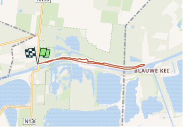
Trail On foot of 5.2 km to be discovered at Flanders, Antwerp, Mol. This trail is proposed by SityTrail - itinéraires balisés pédestres.

Description

Ongelooflijke natuur! Dat zal je slotconclusie zijn na een wandeling op het unieke natuurreservaat ‘Den Diel’.

Website: https://toerisme.gemeentemol.be/aanbod/679/wandeling-den-diel

Elevation profile

Photos

Positioning

Country:
Belgium
Region :
Flanders
Department/Province :
Antwerp
Municipality :
Mol
Location:
Unknown
Start:(UTM)
652624 ; 5678672 (31U) N.


Close
My subscriptions