


MN la demoiselle

GG GPE
User
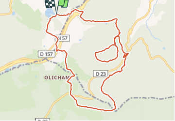

Length
12.5 km

Max alt
733 m

Uphill gradient
333 m
Km-Effort
16.9 km

Min alt
541 m

Downhill gradient
335 m
Boucle
Yes
Creation date :
2022-02-10 08:10:27.942
Updated on :
2022-02-10 10:32:06.209
2h11
Difficulty : Easy

FREE GPS app for hiking
 SityTrail
IGN / Geographical institutes
SityTrail Plus
The world is yours!
About
Trail Nordic walking of 12.5 km to be discovered at Grand Est, Vosges, Saint-Nabord. This trail is proposed by GG GPE.
Description
MN
Positioning
Country:
France
Region :
Grand Est
Department/Province :
Vosges
Municipality :
Saint-Nabord
Location:
Unknown
Start:(Dec)
Start:(UTM)
317016 ; 5319500 (32U) N.
Comments