


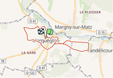
marqueglise

Pachinou
User

Length
7.7 km

Max alt
75 m

Uphill gradient
70 m
Km-Effort
8.7 km

Min alt
48 m

Downhill gradient
72 m
Boucle
Yes
Creation date :
2022-02-10 08:06:00.561
Updated on :
2022-02-10 11:09:20.753
2h00
Difficulty : Medium

FREE GPS app for hiking
 SityTrail
IGN / Geographical institutes
SityTrail Plus
The world is yours!
About
Trail Walking of 7.7 km to be discovered at Hauts-de-France, Oise, Marquéglise. This trail is proposed by Pachinou.
Positioning
Country:
France
Region :
Hauts-de-France
Department/Province :
Oise
Municipality :
Marquéglise
Location:
Unknown
Start:(Dec)
Start:(UTM)
482851 ; 5485002 (31U) N.
Comments