Trail Walking Saint-Symphorien-d'Ancelles - St romain - Photo
© OpenStreetMap contributors
Length
Length
7.1 km
Max alt
Max alt
174 m
Uphill gradient
Uphill gradient
37 m
Km-Effort
Km-Effort  
7.6 km
Min alt
Min alt
166 m
Downhill gradient
Downhill gradient
37 m
Boucle
Boucle
Yes
Creation date :
2022-02-10 12:33:46.135
Updated on :
2022-02-10 14:29:21.682

(0 Reviews)

Walking
Walking
1h51
Difficulty : Medium

Scan this QR Code to open this trail in the SityTrail application

FREE GPS app for hiking

Logo SityTrail SityTrail

IGN / Geographical institutes

Download SityTrail from the App Store Download SityTrail from Google Play

Logo SityTrail SityTrail World

The world is yours!

Download SityTrail from the App Store Download SityTrail from Google Play Download SityTrail on Huawei AppGallery

About

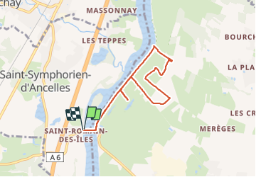
Trail Walking of 7.1 km to be discovered at Bourgogne-Franche-Comté, Saône-et-Loire, Saint-Symphorien-d'Ancelles. This trail is proposed by Chrystele Lafont.

Elevation profile

Photos

Positioning

Country:
France
Region :
Bourgogne-Franche-Comté
Department/Province :
Saône-et-Loire
Municipality :
Saint-Symphorien-d'Ancelles
Location:
Saint-Romain-des-Îles
Start:(UTM)
637236 ; 5116530 (31T) N.

Trails nearby

Trail Road bike Cormoranche-sur-Saône - 01 voie verte et bleue macon - Photo
Road bike
himba26100

Road bike

Medium
Cormoranche-sur-Saône, Auvergne-Rhône-Alpes, Ain, France
74 km | 84 km-effort
4h 45min
Yes
Trail Walking La Chapelle-de-Guinchay - 10 - Photo
Walking
Chrystele Lafont

Walking

Medium
La Chapelle-de-Guinchay, Bourgogne-Franche-Comté, Saône-et-Loire, France
9.8 km | 11.2 km-effort
2h 41min
Yes
Trail Walking La Chapelle-de-Guinchay - massonay - Photo
Walking
Chrystele Lafont

Walking

Medium
La Chapelle-de-Guinchay, Bourgogne-Franche-Comté, Saône-et-Loire, France
9 km | 9.7 km-effort
2h 19min
Yes
Trail Walking La Chapelle-de-Guinchay - creches - Photo
Walking
Chrystele Lafont

Walking

Difficult
La Chapelle-de-Guinchay, Bourgogne-Franche-Comté, Saône-et-Loire, France
11.3 km | 12.2 km-effort
2h 53min
Yes
Trail Walking La Chapelle-de-Guinchay - 8 - Photo
Walking
Chrystele Lafont

Walking

Medium
La Chapelle-de-Guinchay, Bourgogne-Franche-Comté, Saône-et-Loire, France
7.6 km | 8.9 km-effort
1h 58min
Yes
Trail Walking Saint-Didier-sur-Chalaronne - Saint-Étienne-sur- Chalaronne  (9,8 km D. 75 m) - Photo
Walking
Thomasdanielle

Walking

Easy
Saint-Didier-sur-Chalaronne, Auvergne-Rhône-Alpes, Ain, France
9.8 km | 10.8 km-effort
2h 48min
Yes
Trail Walking Chénas - Chénas (16 km D. 500 m ) - Photo
Walking
Thomasdanielle

Walking

Difficult
Chénas, Auvergne-Rhône-Alpes, Rhône, France
16.5 km | 23 km-effort
4h 57min
Yes
Trail Coupling Garnerans - Beau Dimanche 2023 attelages-16167373 - Photo
Coupling
Ferme-Passion

Coupling

Very easy
Garnerans, Auvergne-Rhône-Alpes, Ain, France
28 km | 32 km-effort
Unknown
Yes
Trail Bicycle tourism Lancié - Lancié > Les Rousses - Photo
Bicycle tourism
Nicolas Bajard

Bicycle tourism

Difficult
Lancié, Auvergne-Rhône-Alpes, Rhône, France
148 km | 192 km-effort
Unknown
No


Close
My subscriptions