


chateaudouble marches

aldaus
User
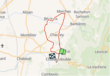

Length
24 km

Max alt
433 m

Uphill gradient
336 m
Km-Effort
28 km

Min alt
240 m

Downhill gradient
305 m
Boucle
No
Creation date :
2022-02-10 13:12:16.176
Updated on :
2022-02-10 14:52:45.746
1h39
Difficulty : Medium

FREE GPS app for hiking
 SityTrail
IGN / Geographical institutes
SityTrail Plus
The world is yours!
About
Trail Mountain bike of 24 km to be discovered at Auvergne-Rhône-Alpes, Drôme, Châteaudouble. This trail is proposed by aldaus.
Positioning
Country:
France
Region :
Auvergne-Rhône-Alpes
Department/Province :
Drôme
Municipality :
Châteaudouble
Location:
Unknown
Start:(Dec)
Start:(UTM)
665511 ; 4974021 (31T) N.
Comments