


croix de chirol

jphugon
User
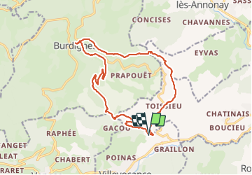

Length
17.7 km

Max alt
947 m

Uphill gradient
682 m
Km-Effort
27 km

Min alt
415 m

Downhill gradient
684 m
Boucle
Yes
Creation date :
2022-02-10 08:33:40.106
Updated on :
2022-02-10 15:39:04.66
7h04
Difficulty : Very difficult

FREE GPS app for hiking
 SityTrail
IGN / Geographical institutes
SityTrail Plus
The world is yours!
About
Trail Walking of 17.7 km to be discovered at Auvergne-Rhône-Alpes, Ardèche, Villevocance. This trail is proposed by jphugon.
Photos


Positioning
Country:
France
Region :
Auvergne-Rhône-Alpes
Department/Province :
Ardèche
Municipality :
Villevocance
Location:
Unknown
Start:(Dec)
Start:(UTM)
625625 ; 5010675 (31T) N.
Comments