


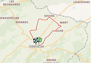
valensol

mcterret
User

Length
10.6 km

Max alt
628 m

Uphill gradient
103 m
Km-Effort
12.1 km

Min alt
544 m

Downhill gradient
138 m
Boucle
No
Creation date :
2022-02-11 13:16:45.843
Updated on :
2022-02-11 16:15:37.214
2h58
Difficulty : Very easy

FREE GPS app for hiking
 SityTrail
IGN / Geographical institutes
SityTrail Plus
The world is yours!
About
Trail Walking of 10.6 km to be discovered at Provence-Alpes-Côte d'Azur, Alpes-de-Haute-Provence, Valensole. This trail is proposed by mcterret.
Positioning
Country:
France
Region :
Provence-Alpes-Côte d'Azur
Department/Province :
Alpes-de-Haute-Provence
Municipality :
Valensole
Location:
Unknown
Start:(Dec)
Start:(UTM)
739811 ; 4858304 (31T) N.
Comments