


Mulartshütte A2

SityTrail - itinéraires balisés pédestres
Tous les sentiers balisés d’Europe GUIDE+
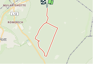

Length
5.6 km

Max alt
402 m

Uphill gradient
80 m
Km-Effort
6.7 km

Min alt
339 m

Downhill gradient
80 m
Boucle
Yes

Signpost
Creation date :
2022-02-11 16:25:54.706
Updated on :
2022-02-11 16:25:54.706
1h31
Difficulty : Easy

FREE GPS app for hiking
 SityTrail
IGN / Geographical institutes
SityTrail Plus
The world is yours!
About
Trail On foot of 5.6 km to be discovered at North Rhine-Westphalia, Städteregion Aachen, Roetgen. This trail is proposed by SityTrail - itinéraires balisés pédestres.
Description
Symbol: weisses A2 auf natur (teilweise auf schwarz)
Photos

Positioning
Country:
Germany
Region :
North Rhine-Westphalia
Department/Province :
Städteregion Aachen
Municipality :
Roetgen
Location:
Unknown
Start:(Dec)
Start:(UTM)
305170 ; 5619752 (32U) N.
Comments