


Signal de saint André

psesjs
User
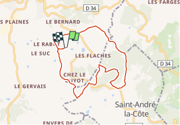

Length
8.6 km

Max alt
931 m

Uphill gradient
235 m
Km-Effort
11.8 km

Min alt
766 m

Downhill gradient
237 m
Boucle
Yes
Creation date :
2022-02-11 13:45:20.0
Updated on :
2022-02-11 16:43:02.399
2h16
Difficulty : Very easy

FREE GPS app for hiking
 SityTrail
IGN / Geographical institutes
SityTrail Plus
The world is yours!
About
Trail Walking of 8.6 km to be discovered at Auvergne-Rhône-Alpes, Rhône, Saint-Martin-en-Haut. This trail is proposed by psesjs.
Description
Belle rando avec beaux panoramas sur les monts du lyonnais et Pilât
Positioning
Country:
France
Region :
Auvergne-Rhône-Alpes
Department/Province :
Rhône
Municipality :
Saint-Martin-en-Haut
Location:
Unknown
Start:(Dec)
Start:(UTM)
622891 ; 5055813 (31T) N.
Comments
balade sympa toutefois trop de routes et difficultée pour se garer
très belle randonnée sans difficultée mais attention au point de départ et d'arrivée qui se situe au niveau de la ferme des brosses propriété privée. Il faut donc prévoir un autre point de parking sur le tracé de la randonnée.