Trail On foot Gilching - Via Zeitreise Gelbe Route - Photo

Via Zeitreise Gelbe Route

Tous les sentiers balisés d’Europe PRO

© OpenStreetMap contributors
Length
Length
9.7 km
Max alt
Max alt
621 m
Uphill gradient
Uphill gradient
157 m
Km-Effort
Km-Effort  
11.8 km
Min alt
Min alt
554 m
Downhill gradient
Downhill gradient
156 m
Boucle
Boucle
Yes
Signpost
Signpost
Creation date :
2022-02-11 17:11:19.282
Updated on :
2022-02-11 17:11:19.282

(0 Reviews)

On foot
On foot
2h40
Difficulty : Easy

Scan this QR Code to open this trail in the SityTrail application

FREE GPS app for hiking

Logo SityTrail SityTrail

IGN / Geographical institutes

Download SityTrail from the App Store Download SityTrail from Google Play

Logo SityTrail SityTrail World

The world is yours!

Download SityTrail from the App Store Download SityTrail from Google Play Download SityTrail on Huawei AppGallery

About

Trail On foot of 9.7 km to be discovered at Bavaria, Landkreis Starnberg, Gilching. This trail is proposed by SityTrail - itinéraires balisés pédestres.

Description

Trail created by Zeitreise Gilching e.V..


Website: https://www.zeitreise-gilching.de/geschichte-erleben/in-gilching/gelbe-route/

Photos

Positioning

Country:
Germany
Region :
Bavaria
Department/Province :
Landkreis Starnberg
Municipality :
Gilching
Location:
Unknown
Start:(UTM)
672756 ; 5330764 (32U) N.

Trails nearby

Trail On foot Gilching - Via Zeitreise - Blaue Route - Photo
On foot
PRO

On foot

Easy
Gilching, Bavaria, Landkreis Starnberg, Germany
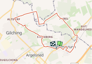
13.2 km | 15.5 km-effort
3h 31min
No
Trail On foot Gilching - Via Zeitreise Rote Route - Photo
On foot
PRO

On foot

Easy
Gilching, Bavaria, Landkreis Starnberg, Germany
9.3 km | 10.8 km-effort
2h 27min
No
Trail On foot Krailling - Hügelgräber im Kreuzlinger Forst - Photo
On foot
PRO

On foot

Easy
Krailling, Bavaria, Landkreis Starnberg, Germany
12.4 km | 14.2 km-effort
3h 14min
Yes


Close
My subscriptions