


St Floret-Blesle

ARVIEU
User
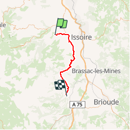

Length
43 km

Max alt
703 m

Uphill gradient
924 m
Km-Effort
55 km

Min alt
426 m

Downhill gradient
904 m
Boucle
No
Creation date :
2014-12-10 00:00:00.0
Updated on :
2014-12-10 00:00:00.0
3h34
Difficulty : Medium

FREE GPS app for hiking
 SityTrail
IGN / Geographical institutes
SityTrail Plus
The world is yours!
About
Trail Mountain bike of 43 km to be discovered at Auvergne-Rhône-Alpes, Puy-de-Dôme, Saint-Floret. This trail is proposed by ARVIEU.
Positioning
Country:
France
Region :
Auvergne-Rhône-Alpes
Department/Province :
Puy-de-Dôme
Municipality :
Saint-Floret
Location:
Unknown
Start:(Dec)
Start:(UTM)
508257 ; 5044144 (31T) N.
Comments