Trail Walking Miglieglia - w10_31_tamaro - Photo

Optez pour le retour à la nature GUIDE+
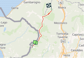
© OpenStreetMap contributors
Length
Length
13 km
Max alt
Max alt
1932 m
Uphill gradient
Uphill gradient
854 m
Km-Effort
Km-Effort  
25 km
Min alt
Min alt
1476 m
Downhill gradient
Downhill gradient
882 m
Boucle
Boucle
No
Creation date :
2014-12-10 00:00:00.0
Updated on :
2014-12-10 00:00:00.0

(0 Reviews)

Walking
Walking
5h51
Difficulty : Unknown

Scan this QR Code to open this trail in the SityTrail application

FREE GPS app for hiking

Logo SityTrail SityTrail

IGN / Geographical institutes

Download SityTrail from the App Store Download SityTrail from Google Play

Logo SityTrail SityTrail Plus

The world is yours!

Download SityTrail from the App Store Download SityTrail from Google Play Download SityTrail on Huawei AppGallery

About

Trail Walking of 13 km to be discovered at Ticino, Distretto di Lugano, Miglieglia. This trail is proposed by My Switzerland.

Elevation profile

Points of interest

Point of interest Monteceneri - Ristorante Alpe Foppa - Photo
My Switzerland
Point of interest Miglieglia - Ristorante Ostello Vetta - Photo
My Switzerland
Point of interest Mezzovico-Vira - Monte Tamaro UTOE - Photo
My Switzerland
MEZZOVICO-VIRA 
Point of interest Monteceneri - Ristorante Bricola - Photo
My Switzerland
MONTECENERI 
Point of interest Novaggio - Ristorante Belcantone - Photo
My Switzerland

Positioning

Country:
Switzerland
Region :
Ticino
Department/Province :
Distretto di Lugano
Municipality :
Miglieglia
Location:
Unknown
Start:(UTM)
487246 ; 5098552 (32T) N.


Close
My subscriptions