Trail Walking Triesenberg - w10_15_gina_malbun - Photo

Optez pour le retour à la nature GUIDE+
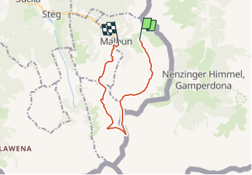
© OpenStreetMap contributors
Length
Length
9.5 km
Max alt
Max alt
2350 m
Uphill gradient
Uphill gradient
531 m
Km-Effort
Km-Effort  
17.8 km
Min alt
Min alt
1607 m
Downhill gradient
Downhill gradient
907 m
Boucle
Boucle
No
Creation date :
2014-12-11 00:00:00.0
Updated on :
2014-12-11 00:00:00.0

(0 Reviews)

Walking
Walking
3h53
Difficulty : Unknown

Scan this QR Code to open this trail in the SityTrail application

FREE GPS app for hiking

Logo SityTrail SityTrail

IGN / Geographical institutes

Download SityTrail from the App Store Download SityTrail from Google Play

Logo SityTrail SityTrail Plus

The world is yours!

Download SityTrail from the App Store Download SityTrail from Google Play Download SityTrail on Huawei AppGallery

About

Trail Walking of 9.5 km to be discovered at Unknown, Oberland, Triesenberg. This trail is proposed by My Switzerland.

Elevation profile

Points of interest

Point of interest Triesenberg - Alpenhotel Malbun - Photo
My Switzerland
TRIESENBERG 
Point of interest Triesenberg - Restaurant Walserhof - Photo
My Switzerland
Point of interest Triesenberg - Bergrestaurant Sareiserjoch - Photo
My Switzerland
Point of interest Schaan - Pfälzerhütte Bettlerjoch - Photo
My Switzerland
Point of interest Triesenberg - Restaurant Gorfion - Photo
My Switzerland
TRIESENBERG 
Point of interest Triesenberg - Restaurant Falknerei Galina - Photo
My Switzerland
Point of interest Triesenberg - Restaurant Turna - Photo
My Switzerland
TRIESENBERG 

Positioning

Country:
Liechtenstein
Region :
Unknown
Department/Province :
Oberland
Municipality :
Triesenberg
Location:
Unknown
Start:(UTM)
547019 ; 5216785 (32T) N.


Close
My subscriptions