


21 km | 27 km-effort
![Trail On foot Puderbach - [B2] Burgweg 2 - Photo](https://media.geolcdn.com/t/1900/400/ext.pjpeg?maxdim=2&url=https%3A%2F%2Fmedia.geolcdn.com%2Ff%2Fbd3a678d-fa90-49ee-85ba-df82f5331819.jpeg)

Tous les sentiers balisés d’Europe PRO


FREE GPS app for hiking
 SityTrail
IGN / Geographical institutes
SityTrail World
The world is yours!
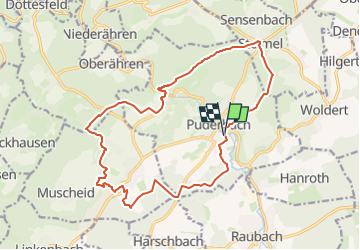
Trail On foot of 16.8 km to be discovered at Rhineland-Palatinate, Landkreis Neuwied, Puderbach. This trail is proposed by SityTrail - itinéraires balisés pédestres.
Trail created by Verbandsgemeinde Puderbach.
Symbol: Symbol "Burg" und Text "2" auf weißem Grund
Website: https://puderbacher-land.de/wandern-im-puderbacher-land/
![Trail On foot Puderbach - [B2] Burgweg 2 - Photo 1](https://media.geolcdn.com/t/2048/auto/fdcfa2db-56e5-4d98-8ae6-d21812145939.jpeg&format=jpg&maxdim=0 "Trail On foot Puderbach - [B2] Burgweg 2 - Photo 1")
![Trail On foot Puderbach - [B2] Burgweg 2 - Photo 2](https://media.geolcdn.com/t/2048/auto/ac8b3803-2b67-4823-b68f-60c5999169fc.jpeg&format=jpg&maxdim=0 "Trail On foot Puderbach - [B2] Burgweg 2 - Photo 2")
![Trail On foot Puderbach - [B2] Burgweg 2 - Photo 3](https://media.geolcdn.com/t/2048/auto/5d0e402c-acd0-4572-8127-64863755e3d7.jpeg&format=jpg&maxdim=0 "Trail On foot Puderbach - [B2] Burgweg 2 - Photo 3")
![Trail On foot Puderbach - [B2] Burgweg 2 - Photo 4](https://media.geolcdn.com/t/2048/auto/bd3a678d-fa90-49ee-85ba-df82f5331819.jpeg&format=jpg&maxdim=0 "Trail On foot Puderbach - [B2] Burgweg 2 - Photo 4")
![Trail On foot Puderbach - [B2] Burgweg 2 - Photo 5](https://media.geolcdn.com/t/2048/auto/1e043d22-e307-4ddb-b427-69201019ca1b.jpeg&format=jpg&maxdim=0 "Trail On foot Puderbach - [B2] Burgweg 2 - Photo 5")
![Trail On foot Puderbach - [B2] Burgweg 2 - Photo 6](https://media.geolcdn.com/t/2048/auto/5084641e-fcfe-4522-9f53-c2dcf9bf8d88.jpeg&format=jpg&maxdim=0 "Trail On foot Puderbach - [B2] Burgweg 2 - Photo 6")
![Trail On foot Puderbach - [B2] Burgweg 2 - Photo 7](https://media.geolcdn.com/t/2048/auto/b44d01e5-107e-429b-8a9d-702e33827965.jpeg&format=jpg&maxdim=0 "Trail On foot Puderbach - [B2] Burgweg 2 - Photo 7")
![Trail On foot Puderbach - [B2] Burgweg 2 - Photo 8](https://media.geolcdn.com/t/2048/auto/18443079-b46f-4f07-b5f1-145b80c44176.jpeg&format=jpg&maxdim=0 "Trail On foot Puderbach - [B2] Burgweg 2 - Photo 8")
![Trail On foot Puderbach - [B2] Burgweg 2 - Photo 9](https://media.geolcdn.com/t/2048/auto/2fdc2868-535f-40cc-9bef-de53fc8a7592.jpeg&format=jpg&maxdim=0 "Trail On foot Puderbach - [B2] Burgweg 2 - Photo 9")
![Trail On foot Puderbach - [B2] Burgweg 2 - Photo 10](https://media.geolcdn.com/t/2048/auto/8502888b-1167-42c9-9076-6b112d1819ef.jpeg&format=jpg&maxdim=0 "Trail On foot Puderbach - [B2] Burgweg 2 - Photo 10")
![Trail On foot Puderbach - [B3] Burgweg 3 - Photo](https://media.geolcdn.com/t/375/260/ext.jpg?maxdim=2&url=https%3A%2F%2Fmedia.geolcdn.com%2Ff%2Fbd3a678d-fa90-49ee-85ba-df82f5331819.jpeg)
On foot
On foot
On foot