DIGNE. Château de la reine Jeanne , hautes bâties du Cousson . chapelle S Jean n

RobinMicheline
User GUIDE
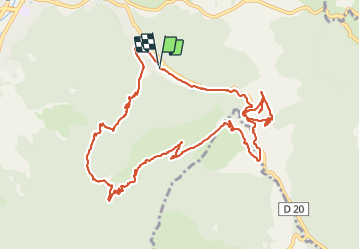

Length
13.2 km

Max alt
1090 m

Uphill gradient
580 m
Km-Effort
21 km

Min alt
627 m

Downhill gradient
581 m
Boucle
Yes
Creation date :
2022-02-12 08:15:23.538
Updated on :
2022-02-12 15:40:31.482
3h46
Difficulty : Medium

FREE GPS app for hiking
 SityTrail
IGN / Geographical institutes
SityTrail Plus
The world is yours!
About
Trail Walking of 13.2 km to be discovered at Provence-Alpes-Côte d'Azur, Alpes-de-Haute-Provence, Digne-les-Bains. This trail is proposed by RobinMicheline.
Photos


Positioning
Country:
France
Region :
Provence-Alpes-Côte d'Azur
Department/Province :
Alpes-de-Haute-Provence
Municipality :
Digne-les-Bains
Location:
Unknown
Start:(Dec)
Start:(UTM)
280185 ; 4884653 (32T) N.
Comments