Trail Walking Veyrier - wa32a - Photo

Optez pour le retour à la nature GUIDE+
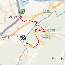
© OpenStreetMap contributors
Length
Length
4.4 km
Max alt
Max alt
1099 m
Uphill gradient
Uphill gradient
683 m
Km-Effort
Km-Effort  
11.3 km
Min alt
Min alt
421 m
Downhill gradient
Downhill gradient
10 m
Boucle
Boucle
No
Creation date :
2014-12-10 00:00:00.0
Updated on :
2014-12-10 00:00:00.0

(0 Reviews)

Walking
Walking
1h54
Difficulty : Unknown

Scan this QR Code to open this trail in the SityTrail application

FREE GPS app for hiking

Logo SityTrail SityTrail

IGN / Geographical institutes

Download SityTrail from the App Store Download SityTrail from Google Play

Logo SityTrail SityTrail Plus

The world is yours!

Download SityTrail from the App Store Download SityTrail from Google Play Download SityTrail on Huawei AppGallery

About

Trail Walking of 4.4 km to be discovered at Geneva, Unknown, Veyrier. This trail is proposed by My Switzerland.

Elevation profile

Points of interest

Point of interest Veyrier - Veyrier - Photo
My Switzerland
VEYRIER 
Point of interest Monnetier-Mornex - Stn. Mont Salève - Photo
My Switzerland
MONNETIER-MORNEX 
Point of interest Monnetier-Mornex -  - Photo
My Switzerland
MONNETIER-MORNEX 

Positioning

Country:
Switzerland
Region :
Geneva
Department/Province :
Unknown
Municipality :
Veyrier
Location:
Unknown
Start:(UTM)
282913 ; 5116409 (32T) N.


Close
My subscriptions