


14011505-coutelière 2022 23 km

jagarnier
User GUIDE
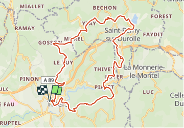


7h20
Difficulty : Difficult

FREE GPS app for hiking
 SityTrail
IGN / Geographical institutes
SityTrail Plus
The world is yours!
About
Trail Walking of 23 km to be discovered at Auvergne-Rhône-Alpes, Puy-de-Dôme, Thiers. This trail is proposed by jagarnier.
Description
Thiers, depuis 6 siècles, a été marqué par ses couteliers, le GMIT (Groupe des Marcheurs Indépendants de Thiers) leur dédie une randonnée avec un parcours recentré sur la région thiernoise, la Vallée des rouets, la Durolle, la cité médiévale, les paysages du Livradois Forez et du val de DORE, ...
A partir de 2005, le club organise la randonnée « La Coutelière » qui se déroule le troisième dimanche de février.
Photos

Positioning
Comments