Trail Walking Arthémonay - Arthemonay - Photo
 meillon
meillon

User

© OpenStreetMap contributors
Length
Length
10.3 km
Max alt
Max alt
469 m
Uphill gradient
Uphill gradient
305 m
Km-Effort
Km-Effort  
14.4 km
Min alt
Min alt
278 m
Downhill gradient
Downhill gradient
303 m
Boucle
Boucle
Yes
Creation date :
2022-02-13 13:36:55.45
Updated on :
2022-02-13 20:15:15.621

(0 Reviews)

Walking
Walking
3h11
Difficulty : Easy

Scan this QR Code to open this trail in the SityTrail application

FREE GPS app for hiking

Logo SityTrail SityTrail

IGN / Geographical institutes

Download SityTrail from the App Store Download SityTrail from Google Play

Logo SityTrail SityTrail World

The world is yours!

Download SityTrail from the App Store Download SityTrail from Google Play Download SityTrail on Huawei AppGallery

About

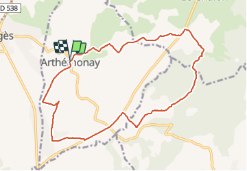
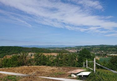
Trail Walking of 10.3 km to be discovered at Auvergne-Rhône-Alpes, Drôme, Arthémonay. This trail is proposed by meillon.

Description

pourtour du village avec traversée du Chalon...

Elevation profile

Photos

Positioning

Country:
France
Region :
Auvergne-Rhône-Alpes
Department/Province :
Drôme
Municipality :
Arthémonay
Location:
Unknown
Start:(UTM)
661533 ; 5000894 (31T) N.

Trails nearby

Trail Walking Geyssans - Geyssans - Photo
Walking
OscarMa

Walking

Very easy
(3)
Geyssans, Auvergne-Rhône-Alpes, Drôme, France
8 km | 10 km-effort
2h 8min
Yes
Trail Walking Saint-Donat-sur-l'Herbasse - lac de champos bois de sizay - Photo
Walking
Gilbertbancilhon

Walking

Very easy
(1)
Saint-Donat-sur-l'Herbasse, Auvergne-Rhône-Alpes, Drôme, France
11.2 km | 14.6 km-effort
3h 1min
Yes
Trail Walking Saint-Donat-sur-l'Herbasse - le bois de Sizay - Photo
Walking
bob2023

Walking

Very easy
Saint-Donat-sur-l'Herbasse, Auvergne-Rhône-Alpes, Drôme, France
6.1 km | 8.6 km-effort
1h 52min
Yes
Trail Walking Saint-Donat-sur-l'Herbasse - champo bois de sizey rb azur  - Photo
Walking
guyzinz

Walking

Medium
Saint-Donat-sur-l'Herbasse, Auvergne-Rhône-Alpes, Drôme, France
14.8 km | 18.3 km-effort
4h 36min
Yes
Trail Walking Crépol - Crepol chapelle Saint Roch - Photo
Walking
meillon

Walking

Easy
Crépol, Auvergne-Rhône-Alpes, Drôme, France
8.3 km | 11.3 km-effort
2h 54min
Yes
Trail Walking Peyrins - Montgrenier - Photo
Walking
meillon

Walking

Easy
Peyrins, Auvergne-Rhône-Alpes, Drôme, France
2.9 km | 3.9 km-effort
1h 5min
Yes
Trail Walking Margès - Boucle De Margès  - Photo
Walking
REYPatrick

Walking

Difficult
Margès, Auvergne-Rhône-Alpes, Drôme, France
12.4 km | 15.5 km-effort
1h 23min
No
Trail Walking Montchenu - 26 chapelle st Roche montchenu - Photo
Walking
himba26100

Walking

Easy
Montchenu, Auvergne-Rhône-Alpes, Drôme, France
12.6 km | 17.3 km-effort
3h 18min
No
Trail Electric bike Crépol - Velo VAE Crepol boucle 45 kms +752 m - Photo
Electric bike
Charignon

Electric bike

Very easy
(1)
Crépol, Auvergne-Rhône-Alpes, Drôme, France
45 km | 55 km-effort
3h 0min
Yes


Close
My subscriptions