


Ferme du Soliat - La Banderette

SityTrail - itinéraires balisés pédestres
Tous les sentiers balisés d’Europe GUIDE+
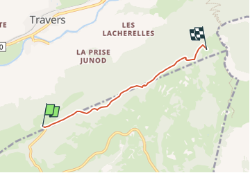

Length
3.8 km

Max alt
1381 m

Uphill gradient
317 m
Km-Effort
7 km

Min alt
1063 m

Downhill gradient
4 m
Boucle
No

Signpost
Creation date :
2022-02-14 08:47:28.321
Updated on :
2022-02-14 08:47:28.321
1h35
Difficulty : Easy

FREE GPS app for hiking
 SityTrail
IGN / Geographical institutes
SityTrail Plus
The world is yours!
About
Trail On foot of 3.8 km to be discovered at Neuchâtel, Unknown, Val-de-Travers. This trail is proposed by SityTrail - itinéraires balisés pédestres.
Description
Trail created by Neuchâtel Rando.
Symbol: losange jaune
Photos


Positioning
Country:
Switzerland
Region :
Neuchâtel
Department/Province :
Unknown
Municipality :
Val-de-Travers
Location:
Unknown
Start:(Dec)
Start:(UTM)
323006 ; 5199246 (32T) N.
Comments