Trail On foot Rhenen - NS-wandeltocht Elsterberg - Photo

NS-wandeltocht Elsterberg

Tous les sentiers balisés d’Europe PRO

© OpenStreetMap contributors
Length
Length
17.7 km
Max alt
Max alt
68 m
Uphill gradient
Uphill gradient
196 m
Km-Effort
Km-Effort  
20 km
Min alt
Min alt
5 m
Downhill gradient
Downhill gradient
214 m
Boucle
Boucle
No
Signpost
Signpost
Creation date :
2022-02-14 14:23:09.395
Updated on :
2022-02-14 14:23:09.395

(0 Reviews)

On foot
On foot
4h38
Difficulty : Medium

Scan this QR Code to open this trail in the SityTrail application

FREE GPS app for hiking

Logo SityTrail SityTrail

IGN / Geographical institutes

Download SityTrail from the App Store Download SityTrail from Google Play

Logo SityTrail SityTrail World

The world is yours!

Download SityTrail from the App Store Download SityTrail from Google Play Download SityTrail on Huawei AppGallery

About

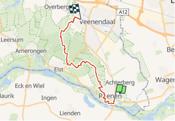
Trail On foot of 17.7 km to be discovered at Utrecht, Unknown, Rhenen. This trail is proposed by SityTrail - itinéraires balisés pédestres.

Description

Klimmen en dalen in de Gelderse Vallei

Website: https://www.ns.nl/dagje-uit/wandelen/elsterberg.html

Photos

Positioning

Country:
Netherlands
Region :
Utrecht
Department/Province :
Unknown
Municipality :
Rhenen
Location:
Unknown
Start:(UTM)
677154 ; 5759480 (31U) N.

Trails nearby

Trail On foot Rhenen - NS-wandeling Blauwe Kamer - Photo
On foot
PRO

On foot

Easy
Rhenen, Utrecht, Unknown, Netherlands
14.6 km | 16.6 km-effort
3h 45min
Yes
Trail On foot Rhenen - Grift en Graftenpad - Photo
On foot
PRO

On foot

Easy
Rhenen, Utrecht, Unknown, Netherlands
11.7 km | 12.9 km-effort
2h 55min
Yes
Trail Walking Rhenen - w-gelderland-rhenen-opheusden - Photo
Walking
gpstracks

Walking

Very easy
(1)
Rhenen, Utrecht, Unknown, Netherlands
12 km | 13.2 km-effort
Unknown
Yes
Trail Walking Rhenen - Utrecht - wandeling Rondje Grebbeberg - Photo
Walking
gpstracks

Walking

Very easy
(1)
Rhenen, Utrecht, Unknown, Netherlands
7.9 km | 9.1 km-effort
Unknown
Yes
Trail Walking Rhenen - Rondje Nederrijn - Photo
Walking
roelvdh

Walking

Easy
Rhenen, Utrecht, Unknown, Netherlands
10 km | 11.2 km-effort
Unknown
Yes
Trail Cycle Rhenen - Utrecht - Griftvalleiroute - Photo
Cycle
gpstracks

Cycle

Very easy
Rhenen, Utrecht, Unknown, Netherlands
23 km | 26 km-effort
Unknown
Yes
Trail Cycle Rhenen - Utrecht - betuwe heuvelrug route - Photo
Cycle
gpstracks

Cycle

Very easy
Rhenen, Utrecht, Unknown, Netherlands
65 km | 70 km-effort
Unknown
Yes
Trail Cycle Neder-Betuwe - Gelderland - Midden-Betuwe - Photo
Cycle
gpstracks

Cycle

Very easy
Neder-Betuwe, Gelderland, Unknown, Netherlands
47 km | 50 km-effort
Unknown
Yes
Trail Cycle Neder-Betuwe - f-zholland-limes-katwijk-nijmegen - Photo
Cycle
gpstracks

Cycle

Very easy
Neder-Betuwe, Gelderland, Unknown, Netherlands
271 km | 285 km-effort
Unknown
No


Close
My subscriptions