


cirque d archiane

mapomme
User
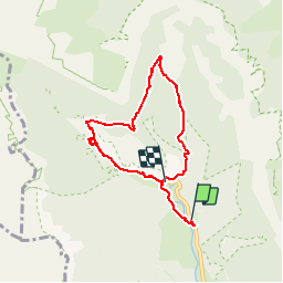

Length
7.2 km

Max alt
1134 m

Uphill gradient
408 m
Km-Effort
12.5 km

Min alt
738 m

Downhill gradient
380 m
Boucle
No
Creation date :
2014-12-10 00:00:00.0
Updated on :
2014-12-10 00:00:00.0
12h28
Difficulty : Unknown

FREE GPS app for hiking
 SityTrail
IGN / Geographical institutes
SityTrail Plus
The world is yours!
About
Trail Walking of 7.2 km to be discovered at Auvergne-Rhône-Alpes, Drôme, Châtillon-en-Diois. This trail is proposed by mapomme.
Description
Belle boucle au pied du cirque-cascade et sous bois. Dénivelé de 300 m qd même .. Donc evitez enfants qui n ont jamais marche ..,
Positioning
Country:
France
Region :
Auvergne-Rhône-Alpes
Department/Province :
Drôme
Municipality :
Châtillon-en-Diois
Location:
Unknown
Start:(Dec)
Start:(UTM)
698622 ; 4957381 (31T) N.
Comments