![](/images/other/stat-length.png)
![Trail On foot Bertiandos - Rota do Solar - Photo](https://media.geolcdn.com/t/1900/400/ext.pjpeg?maxdim=2&url=https%3A%2F%2Fmedia.geolcdn.com%2Ff%2Fabe95b11-3636-4be5-b65b-519aa015dcbb.jpeg)
Rota do Solar
SityTrail - itinéraires balisés pédestres
Tous les sentiers balisés d’Europe PRO
![Length](/images/other/stat-length.png)
![Max alt](https://static1.geolcdn.com/siteimages/upload/files/1508320355ic_sort_altitude_max_24dp.png)
![Uphill gradient](https://static1.geolcdn.com/siteimages/upload/files/1508320355ic_sort_den_pos_24dp.png)
![Km-Effort](/images/other/stat-length.png)
![Min alt](https://static1.geolcdn.com/siteimages/upload/files/1508320355ic_sort_altitude_min_24dp.png)
![Downhill gradient](https://static1.geolcdn.com/siteimages/upload/files/1508320355ic_sort_den_neg_24dp.png)
![Boucle](https://static1.geolcdn.com/siteimages/upload/files/16400158638029165_repeat_loop_refresh_sync_direction_icon.png)
![On foot](https://static1.geolcdn.com/sitytour/trail-icons/100.png)
50m
Difficulty : Easy
![Scan this QR Code to open this trail in the SityTrail application](https://capi.geolives.com/qq0zvz2zws4bq2lad0pu/sitytour/trails/3110097/qr.png?size=200)
FREE GPS app for hiking
About
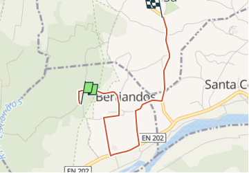
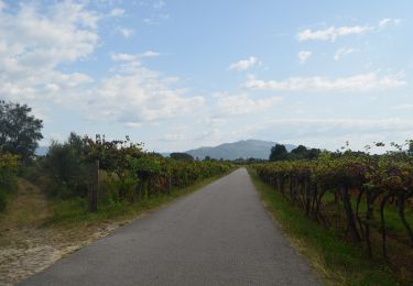
Trail On foot of 3.2 km to be discovered at North, Viana do Castelo, Bertiandos. This trail is proposed by SityTrail - itinéraires balisés pédestres.
Description
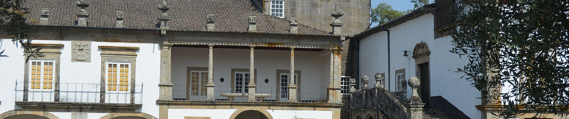
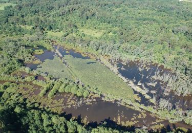
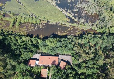
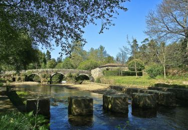
A Rota do Solar é um percurso pedestre denominado de pequena rota. As respetivas marcações e sinalizações obedecem às normas internacionais. O percurso desenvolve-se na zona de influência da Área Protegida das Lagoas de Bertiandos e S. Pedro d?Arcos, dando a conhecer o seu valor natural, e com...;Nome do Percurso: Rota do SolarEntidade Promotora: Município de Ponte de LimaTipo de Percurso: Circular, Pequena RotaÂmbito do Percurso: Ecológico, Histórico, CulturalPonto de Partida/Chegada: Ponte de Esteiro (Junto ao Campo de Futebol das Lagoas)Distância Percorrida: 9,26 KmDuração do Percurso: 4h30mGrau de Dificuldade: FácilCota Máxima Atingida: 38 metrosPontos de interesse1. Ponte de Esteiro2. Solar de Bertiandos e Marco Miliário3. Senhor da Saúde4. Posto de Observação5. Lagoa do Mimoso6. Rio Estorãos7. Centro de Interpretação Ambiental8. Lagoa de S. Pedro de Arcos9. Moinho de MatiasPonto de partida / chegada41° 45' 52,9" N | 8° 37' 46,8" W ;
Website: https://www.visitepontedelima.pt/pt/turismo/rota-do-solar/
Positioning
Comments
Trails nearby
![Trail On foot - Trilho do Lobo Atlântico - Photo](https://media.geolcdn.com/t/375/260/ext.jpg?maxdim=2&url=https%3A%2F%2Fmedia.geolcdn.com%2Ff%2F5ba811a4-fc38-43d0-b473-94c34ec2d7c8.jpeg)
![On foot On foot](https://static1.geolcdn.com/sitytour/trail-icons/100.png)
On foot
![](/images/other/stat-length.png)
![](https://static1.geolcdn.com/siteimages/upload/files/16400158638029165_repeat_loop_refresh_sync_direction_icon.png)
![Trail On foot Estorãos - Percurso do Cerquido - Photo](https://media.geolcdn.com/t/375/260/ext.jpg?maxdim=2&url=https%3A%2F%2Fmedia.geolcdn.com%2Ff%2Fb5326e96-b9f3-40e7-b2ce-f3792d9a22c0.jpeg)
![On foot On foot](https://static1.geolcdn.com/sitytour/trail-icons/100.png)
On foot
![](/images/other/stat-length.png)
![](https://static1.geolcdn.com/siteimages/upload/files/16400158638029165_repeat_loop_refresh_sync_direction_icon.png)
![Trail On foot São Pedro d'Arcos - Percurso da Veiga - Photo](https://media.geolcdn.com/t/375/260/ext.jpg?maxdim=2&url=https%3A%2F%2Fmedia.geolcdn.com%2Ff%2F1e3c5b11-5a8f-4ee9-93e7-d75ccf5000ba.jpeg)
![On foot On foot](https://static1.geolcdn.com/sitytour/trail-icons/100.png)
On foot
![](/images/other/stat-length.png)
![](https://static1.geolcdn.com/siteimages/upload/files/16400158638029165_repeat_loop_refresh_sync_direction_icon.png)
![Trail On foot Estorãos - Percurso da Água - Photo](https://media.geolcdn.com/t/375/260/ext.jpg?maxdim=2&url=https%3A%2F%2Fmedia.geolcdn.com%2Ff%2Fffe2547d-0da3-40ae-99ba-c29258f17f28.jpeg)
![On foot On foot](https://static1.geolcdn.com/sitytour/trail-icons/100.png)
On foot
![](/images/other/stat-length.png)
![](https://static1.geolcdn.com/siteimages/upload/files/16400158638029165_repeat_loop_refresh_sync_direction_icon.png)
![Trail On foot São Pedro d'Arcos - Percurso das Tapadas - Photo](https://media.geolcdn.com/t/375/260/ext.jpg?maxdim=2&url=https%3A%2F%2Fmedia.geolcdn.com%2Ff%2F786becdd-e4f5-4fa3-a54c-e4527150937c.jpeg)
![On foot On foot](https://static1.geolcdn.com/sitytour/trail-icons/100.png)
On foot
![](/images/other/stat-length.png)
![](https://static1.geolcdn.com/siteimages/upload/files/16400158638029165_repeat_loop_refresh_sync_direction_icon.png)
![Trail On foot Estorãos - Rota da Azenha - Photo](https://media.geolcdn.com/t/375/260/ext.jpg?maxdim=2&url=https%3A%2F%2Fmedia.geolcdn.com%2Ff%2Fc0beb203-4962-49e6-ae66-0755f3c71f4e.jpeg)
![On foot On foot](https://static1.geolcdn.com/sitytour/trail-icons/100.png)
On foot
![](/images/other/stat-length.png)
![](https://static1.geolcdn.com/siteimages/upload/files/16400158638029165_repeat_loop_refresh_sync_direction_icon.png)
![Trail Walking Arca e Ponte de Lima - Chemin Portugais 9 Barcelos - Photo](https://media.geolcdn.com/t/375/260/ext.jpg?maxdim=2&url=https%3A%2F%2Fstatic1.geolcdn.com%2Fsiteimages%2Fupload%2Ffiles%2F1553511878bg_sport_marche.png)
![Walking Walking](https://static1.geolcdn.com/sitytour/trail-icons/101.png)
Walking
![](/images/other/stat-length.png)
![](https://static1.geolcdn.com/siteimages/upload/files/16400158638029165_repeat_loop_refresh_sync_direction_icon.png)
![Trail Walking Arca e Ponte de Lima - PONTE DE LIMA - RUBIAES - Photo](https://media.geolcdn.com/t/375/260/ext.jpg?maxdim=2&url=https%3A%2F%2Fstatic1.geolcdn.com%2Fsiteimages%2Fupload%2Ffiles%2F1553511878bg_sport_marche.png)
![Walking Walking](https://static1.geolcdn.com/sitytour/trail-icons/101.png)
Walking
![](/images/other/stat-length.png)
![](https://static1.geolcdn.com/siteimages/upload/files/16400158638029165_repeat_loop_refresh_sync_direction_icon.png)