


ZR17 Rochejean

i20
User
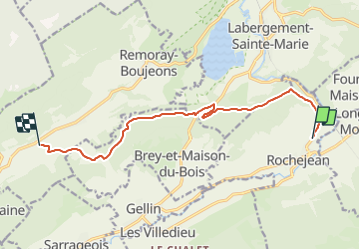

Length
10.6 km

Max alt
1012 m

Uphill gradient
243 m
Km-Effort
13.7 km

Min alt
868 m

Downhill gradient
199 m
Boucle
No
Creation date :
2022-02-14 22:12:30.881
Updated on :
2022-02-14 22:13:20.222
--
Difficulty : Difficult

FREE GPS app for hiking
 SityTrail
IGN / Geographical institutes
SityTrail Plus
The world is yours!
About
Trail Car of 10.6 km to be discovered at Bourgogne-Franche-Comté, Doubs, Rochejean. This trail is proposed by i20.
Positioning
Country:
France
Region :
Bourgogne-Franche-Comté
Department/Province :
Doubs
Municipality :
Rochejean
Location:
Unknown
Start:(Dec)
Start:(UTM)
293532 ; 5180966 (32T) N.
Comments