


IT-744

SityTrail - itinéraires balisés pédestres
Tous les sentiers balisés d’Europe GUIDE+

Length
16.6 km

Max alt
859 m

Uphill gradient
819 m
Km-Effort
28 km

Min alt
391 m

Downhill gradient
879 m
Boucle
No

Signpost
Creation date :
2022-02-14 23:35:50.459
Updated on :
2022-02-28 18:10:05.469
6h18
Difficulty : Medium

FREE GPS app for hiking
 SityTrail
IGN / Geographical institutes
SityTrail Plus
The world is yours!
About
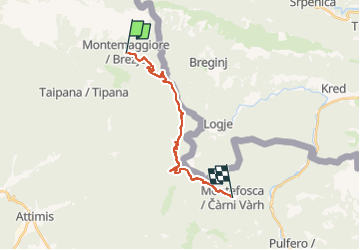
Trail On foot of 16.6 km to be discovered at Friuli Venezia Giulia, Unknown, Taipana. This trail is proposed by SityTrail - itinéraires balisés pédestres.
Description
Trail created by Club Alpino Italiano.
Photos

Positioning
Country:
Italy
Region :
Friuli Venezia Giulia
Department/Province :
Unknown
Municipality :
Taipana
Location:
Unknown
Start:(Dec)
Start:(UTM)
374420 ; 5125023 (33T) N.
Comments