


IT-640

SityTrail - itinéraires balisés pédestres
Tous les sentiers balisés d’Europe GUIDE+
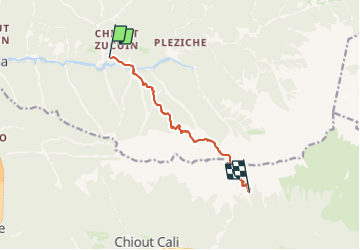

Length
8.2 km

Max alt
2120 m

Uphill gradient
1756 m
Km-Effort
28 km

Min alt
557 m

Downhill gradient
781 m
Boucle
No

Signpost
Creation date :
2022-02-15 00:05:12.284
Updated on :
2022-02-28 18:29:13.065
6h27
Difficulty : Medium

FREE GPS app for hiking
 SityTrail
IGN / Geographical institutes
SityTrail Plus
The world is yours!
About
Trail On foot of 8.2 km to be discovered at Friuli Venezia Giulia, Unknown, Dogna. This trail is proposed by SityTrail - itinéraires balisés pédestres.
Description
Trail created by Club Alpino Italiano.
Symbol: red white red 640
Positioning
Country:
Italy
Region :
Friuli Venezia Giulia
Department/Province :
Unknown
Municipality :
Dogna
Location:
Unknown
Start:(Dec)
Start:(UTM)
373812 ; 5145230 (33T) N.
Comments