Trail On foot Valbonne - Circuit de l'Aqueduc - Photo

Tous les sentiers balisés d’Europe PRO

© OpenStreetMap contributors
Length
Length
6.3 km
Max alt
Max alt
145 m
Uphill gradient
Uphill gradient
125 m
Km-Effort
Km-Effort  
8 km
Min alt
Min alt
75 m
Downhill gradient
Downhill gradient
125 m
Boucle
Boucle
Yes
Signpost
Signpost
Creation date :
2022-02-15 00:23:59.873
Updated on :
2022-03-02 09:44:23.862

(0 Reviews)

On foot
On foot
1h49
Difficulty : Easy

Scan this QR Code to open this trail in the SityTrail application

FREE GPS app for hiking

Logo SityTrail SityTrail

IGN / Geographical institutes

Download SityTrail from the App Store Download SityTrail from Google Play

Logo SityTrail SityTrail World

The world is yours!

Download SityTrail from the App Store Download SityTrail from Google Play Download SityTrail on Huawei AppGallery

About

Trail On foot of 6.3 km to be discovered at Provence-Alpes-Côte d'Azur, Maritime Alps, Valbonne. This trail is proposed by SityTrail - itinéraires balisés pédestres.

Photos

Positioning

Country:
France
Region :
Provence-Alpes-Côte d'Azur
Department/Province :
Maritime Alps
Municipality :
Valbonne
Location:
Unknown
Start:(UTM)
343049 ; 4830207 (32T) N.

Trails nearby

Trail On foot Biot - Sentier de la Vallée de la Brague - Photo
On foot
PRO

On foot

Easy
Biot, Provence-Alpes-Côte d'Azur, Maritime Alps, France
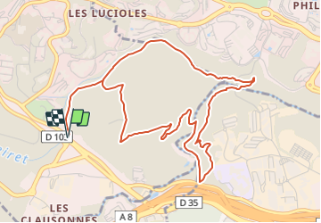
10 km | 12.5 km-effort
2h 50min
No
Trail On foot Valbonne - Circuit des Macarons - Photo
On foot
PRO

On foot

Easy
Valbonne, Provence-Alpes-Côte d'Azur, Maritime Alps, France
6.3 km | 8.6 km-effort
1h 57min
Yes
Trail On foot Valbonne - Circuit des Bouillides - Photo
On foot
PRO

On foot

Easy
Valbonne, Provence-Alpes-Côte d'Azur, Maritime Alps, France
10.6 km | 13.9 km-effort
3h 8min
Yes
Trail On foot Valbonne - Circuit du Bruguet - Photo
On foot
PRO

On foot

Easy
Valbonne, Provence-Alpes-Côte d'Azur, Maritime Alps, France
7.2 km | 9.4 km-effort
2h 7min
Yes
Trail On foot Biot - Circuit de Saint-Philippe - Photo
On foot
PRO

On foot

Easy
Biot, Provence-Alpes-Côte d'Azur, Maritime Alps, France
3.3 km | 4.7 km-effort
1h 4min
No
Trail On foot Biot - Circuit des Pierres à Four - Photo
On foot
PRO

On foot

Easy
Biot, Provence-Alpes-Côte d'Azur, Maritime Alps, France
10.3 km | 13 km-effort
2h 57min
Yes
Trail On foot Valbonne - Circuit de Font Martine - Photo
On foot
PRO

On foot

Easy
Valbonne, Provence-Alpes-Côte d'Azur, Maritime Alps, France
7.9 km | 10 km-effort
2h 16min
Yes
Trail Mountain bike Valbonne - Valmasques pistes carton, Devens, des Moulins... - Photo
Mountain bike
GrouGary

Mountain bike

Easy
(2)
Valbonne, Provence-Alpes-Côte d'Azur, Maritime Alps, France
12.4 km | 15.3 km-effort
1h 53min
Yes
Trail Walking Le Cannet - Sur les pas de Bonnard, Le Cannet - Photo
Walking
GrouGary

Walking

Very easy
(1)
Le Cannet, Provence-Alpes-Côte d'Azur, Maritime Alps, France
4.8 km | 6.3 km-effort
1h 44min
Yes


Close
My subscriptions