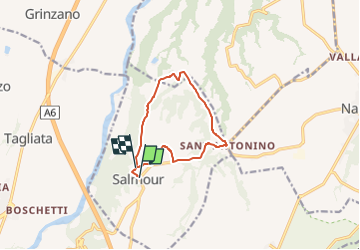
Trail On foot Salmour - Anello di Salmour - Photo

Anello di Salmour

Tous les sentiers balisés d’Europe GUIDE+

© OpenStreetMap contributors
Length
Length
9.7 km
Max alt
Max alt
392 m
Uphill gradient
Uphill gradient
99 m
Km-Effort
Km-Effort  
11.1 km
Min alt
Min alt
322 m
Downhill gradient
Downhill gradient
108 m
Boucle
Boucle
No
Signpost
Signpost
Creation date :
2022-02-15 00:56:24.757
Updated on :
2022-02-28 19:54:43.882

(0 Reviews)

On foot
On foot
2h30
Difficulty : Easy

Scan this QR Code to open this trail in the SityTrail application

FREE GPS app for hiking

Logo SityTrail SityTrail

IGN / Geographical institutes

Download SityTrail from the App Store Download SityTrail from Google Play

Logo SityTrail SityTrail Plus

The world is yours!

Download SityTrail from the App Store Download SityTrail from Google Play Download SityTrail on Huawei AppGallery

About

Trail On foot of 9.7 km to be discovered at Piemont, Cuneo, Salmour. This trail is proposed by SityTrail - itinéraires balisés pédestres.

Description

Il sito del Turismo di Fossano e del Fossanese. Eventi, esperienze di viaggio, cicloturismo, hotel e ristoranti, opportunità di visita e informazioni turistiche

Elevation profile

Photos

Positioning

Country:
Italy
Region :
Piemont
Department/Province :
Cuneo
Municipality :
Salmour
Location:
Unknown
Start:(UTM)
404133 ; 4936826 (32T) N.


Close
My subscriptions