


Chemin de l'Egrenne

SityTrail - itinéraires balisés pédestres
Tous les sentiers balisés d’Europe GUIDE+

Length
10.6 km

Max alt
261 m

Uphill gradient
254 m
Km-Effort
14 km

Min alt
166 m

Downhill gradient
243 m
Boucle
Yes

Signpost
Creation date :
2022-02-15 02:34:56.095
Updated on :
2022-03-02 11:26:43.944
3h10
Difficulty : Easy

FREE GPS app for hiking
 SityTrail
IGN / Geographical institutes
SityTrail Plus
The world is yours!
About
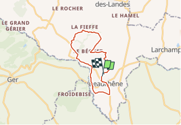
Trail On foot of 10.6 km to be discovered at Normandy, Orne, Tinchebray-Bocage. This trail is proposed by SityTrail - itinéraires balisés pédestres.
Positioning
Country:
France
Region :
Normandy
Department/Province :
Orne
Municipality :
Tinchebray-Bocage
Location:
Beauchêne
Start:(Dec)
Start:(UTM)
667307 ; 5394694 (30U) N.
Comments