Trail On foot Pré-en-Pail-Saint-Samson - Boucle des Eglantiers - Photo

Tous les sentiers balisés d’Europe PRO

© OpenStreetMap contributors
Length
Length
13.9 km
Max alt
Max alt
388 m
Uphill gradient
Uphill gradient
287 m
Km-Effort
Km-Effort  
17.7 km
Min alt
Min alt
210 m
Downhill gradient
Downhill gradient
285 m
Boucle
Boucle
Yes
Signpost
Signpost
Creation date :
2022-02-15 04:50:24.804
Updated on :
2022-03-02 13:16:42.49

(0 Reviews)

On foot
On foot
4h01
Difficulty : Easy

Scan this QR Code to open this trail in the SityTrail application

FREE GPS app for hiking

Logo SityTrail SityTrail

IGN / Geographical institutes

Download SityTrail from the App Store Download SityTrail from Google Play

Logo SityTrail SityTrail World

The world is yours!

Download SityTrail from the App Store Download SityTrail from Google Play Download SityTrail on Huawei AppGallery

About

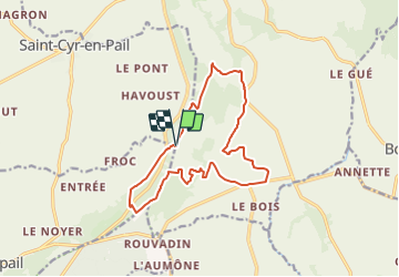
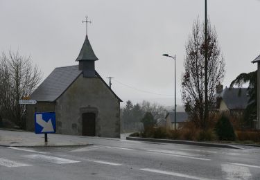
Trail On foot of 13.9 km to be discovered at Pays de la Loire, Mayenne, Pré-en-Pail-Saint-Samson. This trail is proposed by SityTrail - itinéraires balisés pédestres.

Description

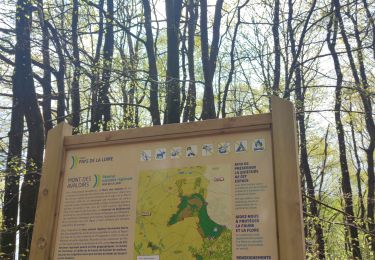
Rejoigez la Communauté de Communes du Mont des Avaloirs, au cœur d'un espace naturel sur le point culminant de l'Ouest, et découvrez ses projets innovants.

Website: http://www.cc-montdesavaloirs.fr/

Photos

Positioning

Country:
France
Region :
Pays de la Loire
Department/Province :
Mayenne
Municipality :
Pré-en-Pail-Saint-Samson
Location:
Pré-en-Pail
Start:(UTM)
706317 ; 5366816 (30U) N.

Trails nearby

Trail On foot Pré-en-Pail-Saint-Samson - Boucle du Bois Goude - Photo
On foot
PRO

On foot

Easy
Pré-en-Pail-Saint-Samson, Pays de la Loire, Mayenne, France
8.8 km | 10.9 km-effort
2h 28min
Yes
Trail On foot Pré-en-Pail-Saint-Samson - Boucle du Belvédère - Photo
On foot
PRO

On foot

Easy
Pré-en-Pail-Saint-Samson, Pays de la Loire, Mayenne, France
7.9 km | 10.1 km-effort
2h 18min
Yes
Trail On foot Pré-en-Pail-Saint-Samson - Circuit des Avaloirs - Photo
On foot
PRO

On foot

Easy
Pré-en-Pail-Saint-Samson, Pays de la Loire, Mayenne, France
11.5 km | 14.9 km-effort
3h 23min
Yes
Trail On foot Pré-en-Pail-Saint-Samson - Boucle de l'Oratoire - Photo
On foot
PRO

On foot

Easy
Pré-en-Pail-Saint-Samson, Pays de la Loire, Mayenne, France
9.9 km | 12.7 km-effort
2h 53min
Yes
Trail On foot Pré-en-Pail-Saint-Samson - Sentier de Prez - Photo
On foot
PRO

On foot

Easy
Pré-en-Pail-Saint-Samson, Pays de la Loire, Mayenne, France
9.1 km | 11.3 km-effort
2h 33min
Yes
Trail On foot Saint-Cyr-en-Pail - Grande Boucle de Saint-Cyr-en-Pail - Photo
On foot
PRO

On foot

Easy
Saint-Cyr-en-Pail, Pays de la Loire, Mayenne, France
12.2 km | 14.6 km-effort
3h 19min
Yes
Trail Walking Crennes-sur-Fraubée - Crennes sur Fraubée - Photo
Walking
PatRando

Walking

Easy
Crennes-sur-Fraubée, Pays de la Loire, Mayenne, France
6.2 km | 7.9 km-effort
1h 28min
Yes
Trail Walking Saint-Cyr-en-Pail - Saint Julien des Eglantiers  - Photo
Walking
MichelRando7656

Walking

Difficult
Saint-Cyr-en-Pail, Pays de la Loire, Mayenne, France
11.9 km | 15.4 km-effort
3h 54min
Yes
Trail Walking Pré-en-Pail-Saint-Samson - Autour du Belvédère  - Photo
Walking
PatRando

Walking

Medium
(1)
Pré-en-Pail-Saint-Samson, Pays de la Loire, Mayenne, France
8.4 km | 10.7 km-effort
1h 35min
Yes


Close
My subscriptions