


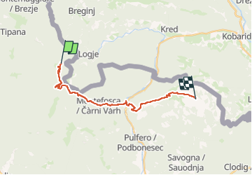
(SI A14) Prossenicco - Rifugio Pelizzo

SityTrail - itinéraires balisés pédestres
Tous les sentiers balisés d’Europe GUIDE+

Length
18.5 km

Max alt
1412 m

Uphill gradient
1738 m
Km-Effort
39 km

Min alt
196 m

Downhill gradient
962 m
Boucle
No

Signpost
Creation date :
2022-02-15 06:34:44.504
Updated on :
2022-03-01 05:36:49.64
8h52
Difficulty : Difficult

FREE GPS app for hiking
 SityTrail
IGN / Geographical institutes
SityTrail Plus
The world is yours!
About
Trail On foot of 18.5 km to be discovered at Friuli Venezia Giulia, Unknown, Taipana. This trail is proposed by SityTrail - itinéraires balisés pédestres.
Description
Sentiero Italia CAI 2019
Photos
 Prossenicco - Rifugio Pelizzo - Photo 1")
 Prossenicco - Rifugio Pelizzo - Photo 2")
 Prossenicco - Rifugio Pelizzo - Photo 3")
 Prossenicco - Rifugio Pelizzo - Photo 4")
 Prossenicco - Rifugio Pelizzo - Photo 5")
 Prossenicco - Rifugio Pelizzo - Photo 6")
Positioning
Country:
Italy
Region :
Friuli Venezia Giulia
Department/Province :
Unknown
Municipality :
Taipana
Location:
Unknown
Start:(Dec)
Start:(UTM)
377132 ; 5120490 (33T) N.
Comments