Trail On foot Château-Thébaud - Le Bois Joly - Photo

Tous les sentiers balisés d’Europe PRO

© OpenStreetMap contributors
Length
Length
6.9 km
Max alt
Max alt
59 m
Uphill gradient
Uphill gradient
94 m
Km-Effort
Km-Effort  
8.2 km
Min alt
Min alt
5 m
Downhill gradient
Downhill gradient
92 m
Boucle
Boucle
Yes
Signpost
Signpost
Creation date :
2022-02-15 10:33:02.818
Updated on :
2022-03-02 15:24:08.638

(0 Reviews)

On foot
On foot
1h51
Difficulty : Easy

Scan this QR Code to open this trail in the SityTrail application

FREE GPS app for hiking

Logo SityTrail SityTrail

IGN / Geographical institutes

Download SityTrail from the App Store Download SityTrail from Google Play

Logo SityTrail SityTrail World

The world is yours!

Download SityTrail from the App Store Download SityTrail from Google Play Download SityTrail on Huawei AppGallery

About

Trail On foot of 6.9 km to be discovered at Pays de la Loire, Loire-Atlantique, Château-Thébaud. This trail is proposed by SityTrail - itinéraires balisés pédestres.

Description

Le vignoble à perte de vue, les plus beaux panoramas sous vos yeux

Website: https://www.levignobledenantes-tourisme.com/circuit-et-randonnee/boucle-circuit-vignoble-du-bois-joli/

Photos

Positioning

Country:
France
Region :
Pays de la Loire
Department/Province :
Loire-Atlantique
Municipality :
Château-Thébaud
Location:
Unknown
Start:(UTM)
619380 ; 5219507 (30T) N.

Trails nearby

Trail On foot Château-Thébaud - Entre Bourg et Maine - Photo
On foot
PRO

On foot

Easy
Château-Thébaud, Pays de la Loire, Loire-Atlantique, France
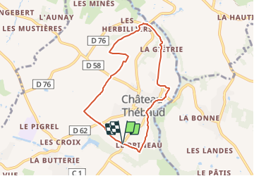
5.9 km | 7 km-effort
1h 35min
No
Trail On foot Maisdon-sur-Sèvre - Soif de Nature - Photo
On foot
PRO

On foot

Easy
Maisdon-sur-Sèvre, Pays de la Loire, Loire-Atlantique, France
14.7 km | 17.1 km-effort
3h 53min
Yes
Trail Walking Château-Thébaud - Château Thébaud_Le bois joli - Photo
Walking
neoroll44

Walking

Medium
(2)
Château-Thébaud, Pays de la Loire, Loire-Atlantique, France
6.8 km | 8.1 km-effort
1h 46min
Yes
Trail Walking Maisdon-sur-Sèvre - Maisdon_Route de la soif - Photo
Walking
neoroll44

Walking

Medium
(1)
Maisdon-sur-Sèvre, Pays de la Loire, Loire-Atlantique, France
13.8 km | 16.1 km-effort
3h 30min
Yes
Trail Walking Saint-Fiacre-sur-Maine - vigne - Photo
Walking
bouchaudpl

Walking

Very easy
(1)
Saint-Fiacre-sur-Maine, Pays de la Loire, Loire-Atlantique, France
19.5 km | 23 km-effort
3h 41min
No
Trail On foot Saint-Lumine-de-Clisson - Circuit des Coteaux Luminais - Photo
On foot
PRO

On foot

Easy
Saint-Lumine-de-Clisson, Pays de la Loire, Loire-Atlantique, France
4.6 km | 5.3 km-effort
1h 12min
Yes
Trail Walking Aigrefeuille-sur-Maine - Aigrefeuille sur Maine - Photo
Walking
PatrickMatuszewski

Walking

Easy
(1)
Aigrefeuille-sur-Maine, Pays de la Loire, Loire-Atlantique, France
10.1 km | 11.4 km-effort
2h 36min
Yes
Trail Walking Saint-Lumine-de-Clisson - Maisdon La Fourère - Photo
Walking
Bernard S

Walking

Easy
Saint-Lumine-de-Clisson, Pays de la Loire, Loire-Atlantique, France
11.6 km | 13.9 km-effort
3h 21min
Yes
Trail sport Maisdon-sur-Sèvre - 2023-03-12_09h35m53_SityTrail - 3559781 - chateauthebaud-01x03x23pluiematin- - Photo
sport
cyrillerandonneur

sport

Very easy
Maisdon-sur-Sèvre, Pays de la Loire, Loire-Atlantique, France
12.5 km | 14.7 km-effort
Unknown
Yes


Close
My subscriptions