


Chemin du Foron

SityTrail - itinéraires balisés pédestres
Tous les sentiers balisés d’Europe GUIDE+
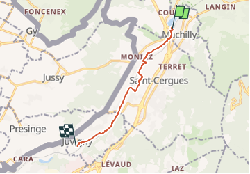

Length
7.1 km

Max alt
533 m

Uphill gradient
24 m
Km-Effort
7.6 km

Min alt
466 m

Downhill gradient
83 m
Boucle
No

Signpost
Creation date :
2022-02-15 11:08:44.16
Updated on :
2022-02-15 11:08:44.16
1h43
Difficulty : Easy

FREE GPS app for hiking
 SityTrail
IGN / Geographical institutes
SityTrail Plus
The world is yours!
About
Trail On foot of 7.1 km to be discovered at Auvergne-Rhône-Alpes, Upper Savoy, Machilly. This trail is proposed by SityTrail - itinéraires balisés pédestres.
Positioning
Country:
France
Region :
Auvergne-Rhône-Alpes
Department/Province :
Upper Savoy
Municipality :
Machilly
Location:
Unknown
Start:(Dec)
Start:(UTM)
294048 ; 5125714 (32T) N.
Comments